The Fair Lawn/Paterson Fish Weir
Bulletin of the Archaeological Society of New Jersey, Vol. 54, 1999
by allen lutins
and
Anthony P. DeCondo
© 1999-2026 allen lutins
The Fair Lawn/Paterson Fish WeirBulletin of the Archaeological Society of New Jersey, Vol. 54, 1999 by allen lutins and
Anthony P. DeCondo © 1999-2026 allen lutins
|
|
 Skinner and Schrabisch, in their 1913 report of archaeological sites in New Jersey, made reference to eleven prehistoric fish traps, or "weirs," in the Passaic River. One of these, the Fair Lawn/Paterson fish weir, is still extant. This report discusses the layout and function of this device, and discusses the evidence for assigning it a prehistoric construction date.
Fish weirs (traps), many built by native Americans prior to European settlement, once abounded on the Passaic River and elsewhere in the region. Until recently such structures were poorly documented, poorly understood, and their importance to reconstructions of regional subsistence and settlement patterns fairly neglected. This study documents one such structure, the Fair Lawn Paterson fish weir (New Jersey State Museum #28-Be-176/28-Pa-147), in detail. This weir is still extant, and in an excellent state of preservation. It spans the Passaic River between the City of Paterson (Passaic County) and Borough of Fair Lawn (Bergen County), in New Jersey, and is usually visible. This paper illustrates how recent studies on weirs and prehistoric fishing serve to shed light on its use by native Americans, and suggests how the weir may contribute to contemporary archaeological studies in the northeast.
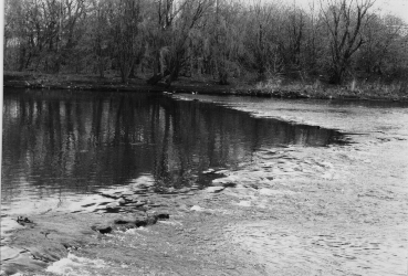
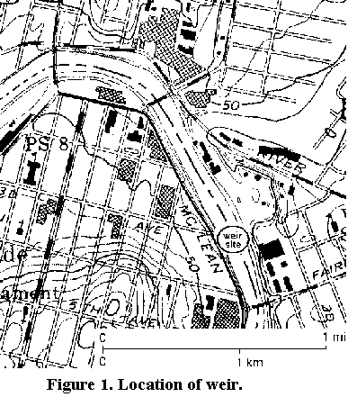
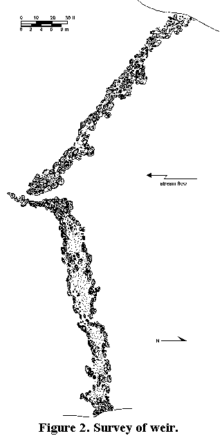
The Fair Lawn/Paterson fish weir (New Jersey State Museum #28-Be-176/28-Pa-147) spans the Passaic River approximately 180 meters (200 yards) north of the Fair Lawn Avenue bridge, straddling the Borough of Fair Lawn (in Bergen County) and the City of Paterson (in Passaic County), in New Jersey (Figure 1). It consists of a "V"-shaped wall of river cobbles and boulders, with its point oriented downstream (Figure 2). The structure spans the entire width of the Passaic River, which at that point is approximately 80 meters (260 feet) wide.
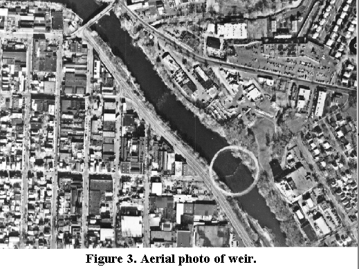
The integrity of the weir is excellent, probably owing to the lack of navigation and industrial impact on this stretch of the river. The alignment of the weir is clear, although a number of the constituent stones, especially near the center portion, became dislodged and repositioned over the years. Local informants note that the structure was altered slightly ca. 1933 when some of the boulders were relocated to allow small watercraft to pass through (Jim D'Ericco, personal communication). The entire structure is often clearly visible, especially at times of low water (Figures 2 and 3). The stones used in its construction consist primarily of glacial material almost certainly obtained from the adjacent river banks.
A large terrace lies adjacent to the weir on the east (Fair Lawn) side. This terrace once contained a rich assemblage of prehistoric archaeological material (characterized by Skinner and Schrabisch as a "workshop"), but all archaeological traces were obliterated by graveling operations undertaken in the 1920s and the subsequent construction of a large industrial facility (still in operation) at that location (Schrabisch 1922; Skinner and Schrabisch 1913:78).
The weir is strategically located to take advantage of favorable hydraulic conditions. Water levels here are relatively shallow throughout most of the year, and the current is slower in relation to points upstream and downstream from the weir (DeCondo 1994).
The region in the vicinity of the Fair Lawn/Paterson fish weir was known to early Dutch settlers as "Sloterdam" ("sluice dam"), a Dutch reference to the similarity of this and other nearby weirs to similar-looking structures in Holland. The earliest known written occurrence of the term "sloterdam" dates to 1708 (Rogers 1960:12), indicating that the term was probably in use beginning in the seventeenth century. The name is found on numerous court documents throughout the eighteenth century, with many variations in spelling e.g., Slotterdam, Slooterdam, and later Slaughterdam). By the latter part of the century, use of the term was in decline. A 1764 Road Return notes that the "Road of Slotterdam," a thoroughfare traversing the length of the Passaic River on its eastern side, was by that time "now known as River Road" (Bergen County Road Returns, Folder B9). The appearance of the term on Erskine's maps (1778-9) is one of the latest known uses (Smullen 1921).
This portion of Bergen County was thinly populated by Dutch farmers through the middle nineteenth century. Use of weirs was and is unknown in Holland (Gerre van der Kle personal communication). There is no mention of the use of any type of weir in the area, nor is there any indication in historic records that large-scale fishing was practiced in this area during the colonial period. (The only known Euro-American use of fish weirs in the state prior to 1800 was by John Read, an agriculturalist from Burlington, New Jersey. In 1763 he began a commercial fishing operation on the Delaware River, employing weirs constructed of mats and nets which in no way resembled the stone weirs found in the Passaic (Woodward 1941:399-400)). In contrast, widespread Native American use of stone weirs was well documented at the time of European contact in this region. It is therefore most likely that the Fair Lawn/Paterson fish weir is of prehistoric origin.
In 1913, Skinner and Schrabisch (1913:75-78) listed eleven stone weirs in the Passaic River. Heusser, writing ten years later, stated that nine of these weirs remained, and noted: "These aboriginal mementos would have been lost sight of, had not the demand for potable water to supply adjoining municipalities depleted the once ample flow of the Passaic" (Heusser 1923:23). Extremely high pollution levels rendered the Passaic unsuitable as a supply of potable water by the mid-twentieth century, returning "the once ample flow;" some of these structures may therefore still remain, albeit submerged. Only one other weir, in the vicinity of the Dundee Dam (approximately 3.8 miles downstream from the Fair-Lawn/Paterson weir), remains visible at times, and this specimen is in an advanced state of disintegration. Photoreconnaissance depicts a well-confined rapids a short distance upstream of the weir which may be the remnants of an additional weir (Figure 3).
Although contact-era accounts often mention Native American use of weirs, they are seldom comprehensive regarding the methodology employed. Most modern references to weir use (e.g., Cross 1965:25; Kraft 1986:76) have their basis in a description by James Adair, who lived among the Choctaw and Cherokee in the early- to mid-eighteenth century. In 1775 he described the use of a temporary brush weir thus:
I have known [Indians] to fasten a wreath of long grape vines together, to reach across the river, with stones fastened at proper distances to rake the bottom; they will swim a mile with it whooping, and plunging all the way, driving the fish before them into their large cane pots.
These "large cane pots" were not analogous to stone structures such as the Fair Lawn/Paterson weir, so it is erroneous to presume that similar methodologies were employed. Given the extent of the spawning runs which took place in rivers (including the Passaic) where stone weirs are found, it is more likely that the primary method employed in their use was not to chase fish into the upstream-facing side of the structure, but rather to wait for spawning runs to conduct large quantities of fish against the downstream side. The use of such a passive method, requiring far less labor than that described in Adair's description, makes more sense, especially considering the numerous contact-era accounts attesting to Native American procurement of fish during spawning runs.
Riverine fish weirs in eastern North America are generally associated with the exploitation of anadromous and catadromous fish (lutins 1982). Anadromous fish are those which migrate upstream from the sea to spawn, and catadromous fish (primarily eels) are those which swim from lakes, rivers and streams out to sea to spawn (McClane 1978). Fisher (1983:36) characterizes anadromous fish as constituting "probably the greatest density of available food that existed for pre-agricultural societies in the Hudson Valley." They are a particularly attractive resource because spawning runs occur within a highly predictable time frame (Fisher 1983:40; Funk 1983:337). These runs can usually be predicted to within a few days' accuracy (Schalk 1977:213).
It is likely that fish played an important role in the diet of the natives living in the vicinity of the Passaic Rivers. Fish are an attractive food source because little risk and effort are expended in catching them (Perlman 1980:260,277). Fish are highly fecund, and are able to repopulate quickly despite heavy predation (Wheeler and Jones 1989:4). Among hunter-gatherer/collectors, the only alternatives providing such high yields per effort expended are deer and nuts (Perlman 1980:281). The absence of tools commonly associated with nut-meat extraction until well into the Middle Woodland period suggests that such resources were not likely utilized before that time in northeastern North America (Funk 1983; Snow 1980).
Numerous contact-era accounts attest to the widespread availability and extensive exploitation of fish throughout the entire Atlantic seaboard (Brumbach 1986:37,42; Bakeless 1961:223,262; Beverley 1705:146). This was especially true in large river basins, such as the Passaic. Jasper Danckaerts, a Labadist missionary, wrote of this area in 1680: "The Indians come up this river in canoes to fish, because it is one of the richest fisheries they have" (De Yoe 1961).
The presence of weirs has implications for the reconstruction not only of subsistence patterns, but for settlement patterns as well. Weir use implies seasonal settlement of at least a portion of the community in the vicinity of the structure in order to attend to such tasks as weir set-up, structural maintenance, and processing of the catch.
Aside from Skinner and Schrabisch's cataloging the structure, archaeologists have paid scant attention to this and similar features in this part of the country. The authors are currently involved in efforts to better document the structure and to nominate it to the National Register of Historic Places. The Fair Lawn/Paterson fish weir has been threatened in the past, particularly by proposed Army Corps flood-control projects which took little or no notice of the structure (USACE 1972; USACE 1987), but no currently proposed projects will threaten the integrity of the weir. Access to the weir site is unrestricted, though, so the potential for damage due to vandalism remains.
The Fair Lawn/Paterson fish weir is important for a number of reasons. Insights into this structure may be of utility for reconstructing inland weir-use, since studies to date on weirs in the northeast have concentrated exclusively on lacustrine and estuarine, rather than riverine, weirs (see, for example, Johnson et al 1942 and Johnston and Cassavoy 1978). In addition, the weir serves to highlight an aspect of prehistoric subsistence practices in an area (the Lower Hudson drainage) where extensive urbanization has severely compromised the integrity of the archaeological record. Finally, the Fair Lawn /Paterson fish weir is one of the few visible remnants of pre-European occupation in the entire northeastern United States.
Much of the background information for this paper derived from allen lutins' M.A. thesis, with additional survey, water flow rate and lithic identification information provided by Anthony DeCondo and Phillip LaPorta. The authors wish to acknowledge Andrew Cartaina for his cartographic assistance, and Aerial Data Reduction Associates, Inc. of Pennsauken, NJ for supplying the photograph used in Figure 3.
 al's home page